Recently, the IIT Delhi team developed India's first national landslide susceptibility map.
In 2023, devastating floods and landslides hit North India during the northeast monsoon, resulting in numerous fatalities. A national landslide susceptibility map would be helpful to identify high-risk areas and enhance mitigation strategies.
FEATURES OF THE NATIONAL LANDSLIDE SUSCEPTIBILITY MAP:
High-Resolution Mapping: The map provides a detailed view of landslide susceptibility across India with a resolution of 100 square meters.
Identification of New Risk Zones: The map not only identifies traditional high-risk landslide areas but also reveals new regions of concern, including previously unrecognized high-risk zones in the Eastern Ghats, near Andhra Pradesh and Odisha.
Innovative Analytical Method: The map was created using an ensemble machine learning approach, which improves prediction accuracy and addresses data gaps in regions not previously charted.
Data Gathering and Analysis: To create this map, researchers compiled data on approximately 150,000 known landslide events. They considered 16 critical factors that influence landslide susceptibility, such as soil type, tree coverage, proximity to roads, and slope steepness.
Future Directions and Accessibility: The team plans to develop a comprehensive Landslide Early Warning System based on this map. Additionally, the map and its data will be made publicly accessible through a web interface to promote public interaction and awareness.
WHAT ARE LANDSLIDES:
The term “landslide” denotes the downward and outward movement of materials including rock, earth or debris down a slope due to gravitational force.
Avalanche is the down slope movement of large detached mass of snow and ice along with rock fragments, soil and vegetation.
They are disasters of Hydrogeological origin, which result in the failure of the materials which fall down the slope due to force of gravity.
INDIA’S VULNERABILITY:
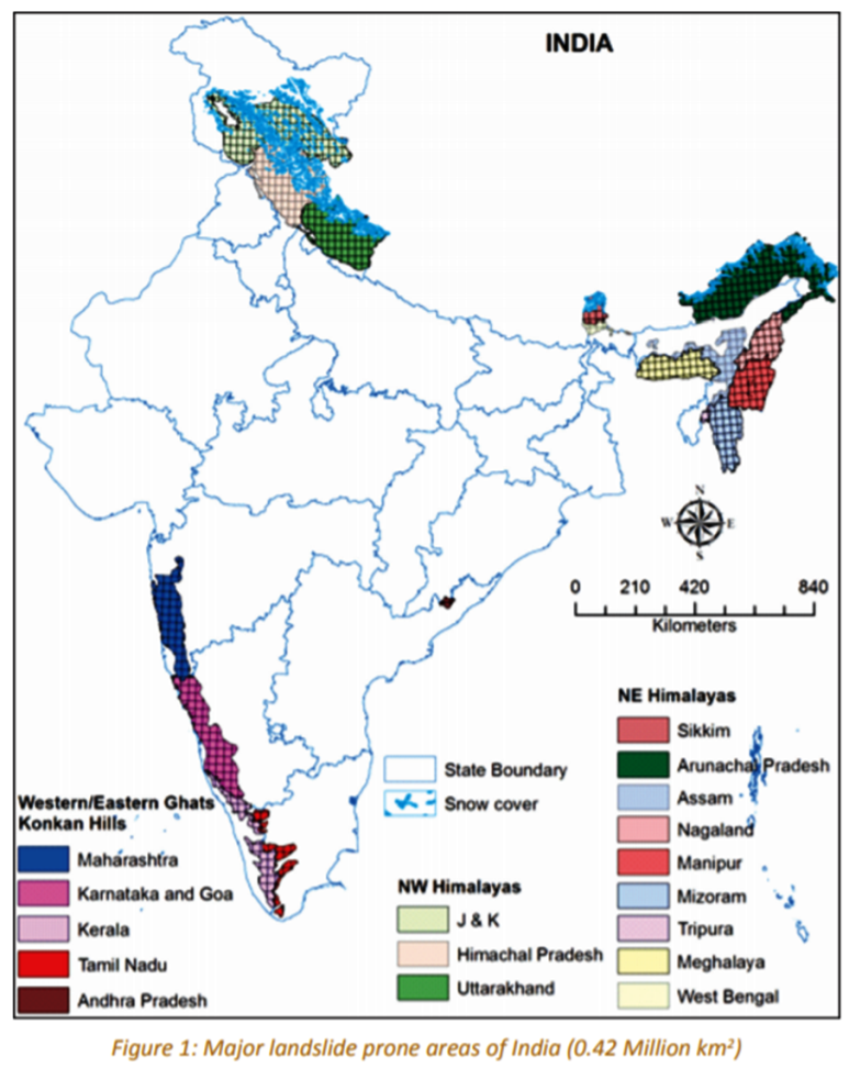
Landslides affect at least 12.6 per cent of the land area of our country—an area which exceeds 0.42 million km2. The phenomenon is pronounced during the monsoon period.
Landslides of different types are frequent in geodynamically active domains in the Himalayan and Arakan-Yoma belt of the North-Eastern parts as well as in the relatively stable domains of the Meghalaya Plateau, Western Ghats and Nilgiri Hills.
The two regions most vulnerable to landslides are the Himalayas and the Western Ghats.
The Himalayan mountain belt is comprised of tectonically unstable younger geological formations subjected to severe seismic activity. The Western Ghats and Nilgiris are geologically stable but have uplifted plateau margins influenced by neo-tectonic activity.
Compared to the Western Ghats region, the slides in the Himalayas region are huge and massive, and in most cases, the overburden along with the underlying lithology is displaced during sliding, particularly due to the seismic factor.
Sporadic occurrences of landslides have been reported in the Eastern Ghats, Ranchi Plateau, and Vindhyan Plateau as well.
The Geological Survey of India (GSI) is the nodal agency for landslide management.
WHAT MAKES INDIA VULNERABLE:
Young geology:
Himalayas are mostly composed of highly unconsolidated sedimentary rocks, which get easily disturbed under stress.
Swift rivers:
The numerous rapid flowing streams in the Himalayan and Western ghats region erodes and undercuts hills, creating steep banks which aid in rapid movement of materials.
Tectonic activities:
Himalayas lie at the convergence zone of the Indian and Eurasian tectonic plates. Hence, the range is geologically very active, resulting in the formation steep slopes, fragile rock structure and rugged topography.
Heavy rainfall:
Water or snowfall can trigger landslides as it alters the pressure within the slope, which leads to slope instability. Also, it can lead to the rise in groundwater levels and formation of water saturated particles. The Himalayas and the Western ghats are among the areas that receive short-period, high-intensity rainfall and hence landslides are frequent here.
Anthropogenic activities:
Deforestation, highway and building excavations, mine-waste piles, open-pit mines and quarries and shifting cultivation result in the region alters the slope and leads to landslides. Also, hydraulic constructions such as Multipurpose dams alters the groundwater levels, thereby aiding landslides.
Forest fires:
Severe wildfires damage the forest canopy, the plants, as well as the soil. The loss of deep-rooted vegetation creates loose soil. These factors can result in increased runoff after intense rainfall or rapid snowmelt, which increases chances of landslides.
NDMA GUIDELINES ON LANDSLIDE MANAGEMENT:
The National Disaster Management Guidelines for Management of Landslides and Snow Avalanches include a wide range of scientific, planning, and administrative tools to address various aspects of these hazards to effectively reduce losses from them.
It includes nine major elements to enhance the effectiveness of managing landslides in the country:
Vulnerability and Risk Assessment: Identify landslide-prone areas, conduct site-specific studies, and create landslide inventories.
Multi-Hazard Conceptualization: Integrate landslide management into broader multi-hazard disaster plans for effective risk assessment and response.
Landslide Remediation Practice: Promote successful landslide mitigation technologies and demonstrate effective strategies to build community confidence.
Research, Development, Monitoring, and Early Warning: Set up a national center for landslide research and management; focus on education, training, and capacity building in this field.
Knowledge Network and Management: Create systems for information collection, loss assessment, and dissemination of landslide data and maps.
Capacity Building and Training: Enhance institutional capacity and provide training for professionals in landslide management; develop and update relevant codes and guidelines.
Public Awareness and Education: Communicate landslide risks through education, awareness programs, media campaigns, and various aids.
Emergency Preparedness and Response: Develop coordinated rapid response capabilities involving various stakeholders for landslide emergencies.
Regulation and Enforcement: Establish a techno-legal framework for landslide hazard assessment and mitigation, with enforceable compliance measures.
OTHER MEASURES TAKEN:
National Landslide Risk Management Strategy:
It is a strategy document by the NDMA to strengthen and mainstream landslide management. Its key aspects include:
Preparation of Landslide Hazard Zonation maps
Developing and implementing Landslide Monitoring and Early Warning System
Participatory approach in awareness generation and preparedness
Management and Inclusion of new technology inputs for capacity building and training programs
Preparation of Mountain Zone Regulations and Policies
Stabilization and Mitigation of Landslide and Creation of Special Purpose Vehicle (SPV) for Landslide Management
Landslide Atlas of India:
The National Remote Sensing Centre (NRSC) under ISRO has released the Landslide Atlas of India in 2023. It is a detailed guide identifying landslide hotspots in the country.
For the first time, scientists did a risk assessment on the basis of 80,000 landslides recorded between 1998 and 2022 in 147 districts in 17 states and two Union Territories to build a "Landslide Atlas" of the country.
The atlas used satellite data of ISRO to map all seasonal and event-based landslides, like the Kedarnath disaster in 2013 and landslides triggered due to the Sikkim earthquake in 2011.
National Landslide Susceptibility Mapping (NLSM) programme:
Geological Survey of India has launched a national programme on landslide susceptibility mapping with an aim to cover the 0.42 million sq. km landslide prone areas of the country. This national programme was formally launched in 2014.
CHALLENGES TO LANDSLIDE MITIGATION & MANAGEMENT:
Ad hoc strategies:
Landslide managementmeasures are generally planned on an ad hoc basis to give immediate relief to affected people. The strategies focus on post disaster relief measures than on pre-disaster risk reduction planning.
Outdated maps:
Majority of the existing Land Zonation Maps (LSZ) lack micro levels details of slopes and landslide events of the past. Also, State-wise and district-wise landslide zonation maps are mostly not available for landslide prone areas.
Weak forecasting:
In Indian Himalayas, the poor network of weather stations and lack of high elevation rain gauges mars the collection of useful data that can help establishing meaningful predictions. Climate change induced variations is worsening this situation.
Poor law enforcement:
Laws exist to regulate activities in landslide-prone areas, but enforcement is lax, as seen in widespread construction, illegal mining, and deforestation in sensitive regions like the Himalayas and Western Ghats.
Lack of Public awareness:
The main cause of losses during landslides is the lack of awareness among the people regarding the potential landslide zones and mitigation strategies, as awareness programmes are not reaching the communities.
Population pressure:
The demand for land in India is severe due to its rising population. Also, hilly areas have economic significance in the form of plantations, timber and construction material. Hence, it is difficult to completely prohibit land use in the areas or enforce stringent environment laws.
WAY FORWARD:
Preparedness-Centric Approach: Implement integrated pre-disaster preparation and disaster risk mitigation strategies as a key aspect of governance and development planning in India.
Research and Development: Establish a national center for landslide research, studies, and management; develop strategies for micro and meso level zonation maps and a landslide database.
Budgetary Allocation: Allocate funds specifically for landslide management in the budgets of Public Works, Irrigation, Rural Engineering Services, and Disaster Management Departments in landslide-prone states.
Forecasting & Early Warning Systems: Enhance forecasting capabilities through maintenance and investment in new systems, and utilize IT tools for real-time data dissemination and warnings.
Techno-Legal Regime: Regulate development in landslide-prone areas with specific land use policies, zoning regulations, and socio-economic profiling of local communities.
Community Participation: Engage local communities and NGOs in awareness and capacity building, including Community Education Programmes in vulnerable areas.
International Cooperation: Facilitate interaction between state governments, NDMA, and international bodies to exchange best practices and advancements in landslide management.
PRACTICE QUESTION:
Q. Discuss the vulnerability of India to landslides. Also, explain the issues associated with landslide mitigation and prevention in the country and suggest solutions.(15 marks, 250 words)