Mitigation of Flood as a Disaster in India
2022 JUN 29
Mains >
Disaster Management > Disaster mitigation > Floods
IN NEWS:
- In the ongoing wave of flooding in Assam, lakhs of people have been affected, and around 1 lakh hectares of crops have been damaged.
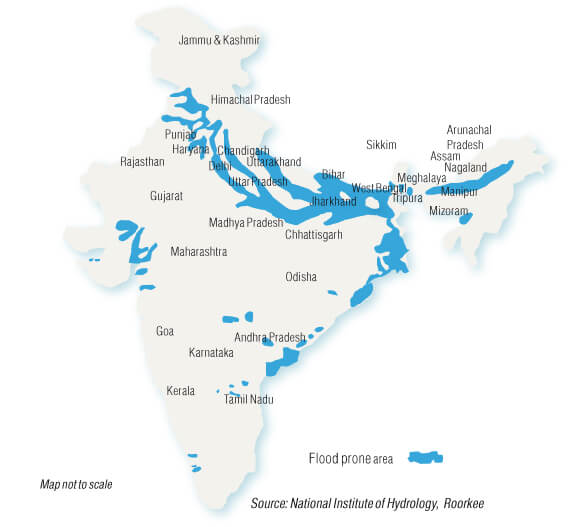
FLOOD PRONE REGIONS IN INDIA:
- India’s unique geo-climatic conditions and high socio-economic vulnerability makes it extremely vulnerable to floods.
- Out of the total geographical area of 329 million hectares (mha), more than 40 mha is flood prone.
- This accounts for 12% of total land area of the country.
- Floods are also occurring in areas which were earlier not considered flood prone.
- Flood prone regions in India can be broadly divided into four regions:
- The Brahmaputra River Region:
- This region consists of the rivers Brahmaputra and Barak and their tributaries, and covers the Northeastern states and northern parts of West Bengal. Floods in this region are severe and quite frequent.
- The Ganga River Region:
- This region consists of the river Ganga and its tributaries.
- The North-west River Region:
- The main rivers in this region are the Indus, Sutlej, Beas, Ravi, Chenab and Jhelum. Compared to the Ganga and the Brahmaputra river regions, the flood problem is relatively less in this region.
- The Central India and Deccan Region:
- Important rivers in this region are the Narmada, Tapi, Mahanadi, Godavari, Krishna and Cauvery
- In addition, the Andaman and Nicobar Islands and Lakshadweep have peculiar characteristics, which result in drainage congestion, flooding and erosion in coastal areas
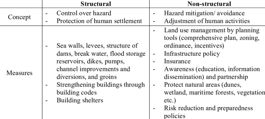
MITIGATION STRATEGIES:
- A multitude of measures are adopted to reduce or mitigate the hazards arising from floods.
- They can be broadly categorized into two: Structural and Non-structural measures.
EXISTING MITIGATION MEASURES IN INDIA:
- Constitutional provisions:
- Unlike irrigation, the subject of flood control does not figure as such in the 7th schedule. However, Drainage and Embankments, are the two measures specifically mentioned in entry 17 of List II.
- Hence, the primary responsibility for flood control lies with the states.
- Ministries:
- The nodal ministry for the disaster management is the Ministry of Home Affairs (MHA).
- Ministry of Jal Shakti along with other department is responsible for the technical aspects flood management.
- The Ministries of Agriculture, Civil Aviation, Environment and Forests, Health, Space, Earth Sciences, Mines, Railways etc. also have important role in management of floods in their respective fields.
- Besides these, states have their own ministries and flood control boards.
- National Disaster Management Authority:
- It is the agency responsible for laying down policies, plans and guidelines for disaster management, coordinating their enforcement and implementation for ensuring a timely and effective response to disasters.
- It has issued guidelines for management of floods.
- National Disaster Response Force under the NDMA is the agency responsible for specialized response to any threatening disasters in India.
- NDMA has released National water policy 2012 suggesting that reservoir operation procedures should be evolved and implemented in a manner so as to have flood cushion and to reduce trapping of sediment during flood season.
- Central Water Commission:
- CWC is the apex agency in the field of water resources including flood management.
- Flood Managment Organisation under the CWC is responsible for techno economic appraisal of flood management projects and multipurpose projects having flood management aspects. It also prepares daily/weekly flood bulletins during flood season and development and improvement of flood forecasting techniques.
- India Meteorological Department:
- The IMD, established in 1875, is the principal government agency in all matters relating to meteorology, seismology and allied subjects.
- It makes observations, give predictions and warn against severe weather phenomena.
- Brahmaputra board:
- The Brahmaputra Board was set up as a statutory body, under the Brahmaputra Board Act, 1980.
- It is responsible for preparation and implementation of plans related to flood management, erosion control, drainage management and water resource development in the Brahmaputra valley.
- Ganga Flood Control Commission (GFCC):
- It is a subordinate office of Ministry of Jal Shakti, created in 1972 to deal with floods and its management in Ganga Basin States.
|
Other major initiatives:
- Chennai became the first city in India to get an intelligent flood warning system.
- Tamil Nadu deployed an ‘intelligent flood warning system’ in Chennai in 2019, which enable officials to get area-wise inundation details during the monsoon.
- The technology, called Coastal Flood Warning System app for Chennai (CFLOWS- CHENNAI), is India’s first integrated coastal flood warning system.
- Mumbai launched the integrated flood warning system (IFLOWS) in June 2020.
- iFLOWS-Mumbai is a state of art webGIS based decision support system to enhance the resilience of Mumbai city by providing early warning for flooding specially during high rainfall events and cyclones.
- The Energy and Resources Institute (TERI) and National Disaster Management Authority (NDMA) have launched a flood early warning system (FEWS) for Guwahati to alert local authorities about flash floods and/or heavy rainfall.
|
CHALLENGES IN FLOOD MANAGEMENT:
- Unregulated development:
- Unabated encroachment of flood plains, reclamation of water bodies, construction of sprawling slums alongside rivers and the shoddy management of storm water drains have led to increased flood risk to lives and properties.
- Relief-centric approach:
- Flood management measures are generally planned on an ad hoc basis to give immediate relief on public demand. Hence, flood management strategies continue to be focused on post disaster relief measures than on pre-disaster planning.
- Unscientific dam management:
- Operation of reservoirs in India is often carried out in an unscientific and knee jerk manner. Despite the mandate of the NDMA, most dams in India do not have any Emergency Action Plans. High reservoir storage and sudden release of water were the root cause for the devastating floods in Kerala in 2018.
- Interstate water disputes:
- Most river basins in India span across various states. However, there is lack of flow of information among the basin-states resulting in gaps in preparedness on their part to face incoming floods.
- Lack of a central agency:
- There is no national or state level institution dealing with all facets of flood management exclusively and in a holistic and comprehensive manner.
- Delays in completion of projects:
- In 2017, the CAG had highlighted the delays in completion of projects under the Flood Management Programme (FMP) due to various reasons such as non-release of funds from the Centre, delays in land acquisitions and inadequate planning.
- Challenges to accurate forecasting:
- Climate change has complicated the flood forecasting and warning systems in India. Also, the network of the CWC, though developed on scientific basis, does not cover all the flood prone rivers. Most of the existing flood forecasting stations are poorly maintained.
- Data deficiency:
- A task force was set up by the CWC in 2006, but it did not complete the task of flood risk mapping. There is no proper documentation about floods, their impact and the manner in which these were tackled.
|
NITI Aayog’s report on strategy for flood management in the country
The recommendations in the report of the committee constituted for Formulation of Strategy for Flood Management Works in Entire Country and River Management Activities and Works Related to Border Areas (2021-26) include,
- Adopting less expensive non-structural measures:
- The report stressed on adopting less expensive non-structural measures like flood forecasting, flood plain zoning, flood proofing to accommodate high spat of water in majority of the places.
- National Water Model:
- The National Water Model (NWM) is a hydrologic modelling framework developed in USA that simulates observed and forecast streamflow over the entire continental United States (CONUS).
- A similar kind of National Water Model may be attempted in India and these models can be used together to feed the information into a decision support system which can provide support services to Nation by predicting and forecasting flood and other water related events.
- Use of advanced technologies:
- It also stressed on the use of advanced technology like artificial intelligence, satellites, remote sensing and GIS for flood forecasting and warning systems.
- Flood cushion in dams:
- The report also pitched for the policy to provide flood cushion in the existing dams to accommodate peak time flood so that the tragedy like Kerala floods doesn't repeat itself.
- Medium term and long-term measures:
- The report pointed out that the construction of embankments/levees should be taken up as the medium-term measures to provide protection to the railway lines, national highways, valuable assets or international boundary.
- Noting that the long-term structural measures like dams, reservoirs, detention basins etc have been used in few cases, the report said the long-term measures should be taken up in the cases where there is compulsion for protection of larger area, population or assets.
|
WAY FORWARD:
- Integrated flood management:
- India needs an integrated approach to managing floods. It would mean thinking simultaneously about water management, physical planning, land use, agriculture, transport and urban development as well as nature conservation.
- Preparedness-centric approach:
- Flood management is yet to be seen as an essential part of good governance and integral to development planning in India.
- There is no national-level flood control authority in the country.
- Forecasting & Early Warning Systems:
- India must improve its flood forecasting capability hugely to minimise loss of lives and property, through better upkeeping of existing systems and investment into new systems.
- Also, IT based tools must be leveraged for the dissemination of real time data and flood warnings.
- Conservation of Water Bodies:
- Water bodies like lakes, tanks and ponds also play a very important role in the management of urban flooding by reducing the stormwater run-off by capturing it.
- Local bodies must be empowered to protect and conserve the water bodies.
- Better cooperation:
- India needs to coordinate with the neighbours for better information, warning and help in managing excess discharge.
- Also, a similar mechanism needs to be developed within the country for strong interstate flood management.
- Develop techno-legal regime:
- The regulation of developmental activities in flood prone areas through an appropriate techno-legal regime is an urgent necessity.
- This can be in the form of specific land use policies, land zoning regulations in flood plains etc.
- National Flood Management Institute:
- An Institute is required to deal with all facets of flood management and serve the purpose of imparting training to the engineers and administrators in all fields of flood management.
|
BEST PRACTICES:
- Buoyant buildings or ‘‘amphibian houses’’ — which sit on dry land but can float vertically during flooding — have been built in Maasbommel, the Netherlands.
- Yonging River Park in Taizhou, China, and the Bishan-Ang Mo Kio Park in Singapore are the urban parks designed as wetlands or floodplains to allow periodic flooding
|
PRACTICE QUESTION:
Q. “Flood management strategies in India continue to be focused on post disaster relief measures than on pre-disaster planning”. Critically analyse.