Recently, the states of Rajasthan and Madhya Pradesh signed a Memorandum of Understanding (MoU) with the Union Ministry of Jal Shakti to implement the Modified Parbati-Kalisindh-Chambal-ERCP (Modified PKC-ERCP) Link Project.
The Modified Parbati-Kalisindh-Chambal-ERCP (PKC-ERCP) Link Project, involving Rajasthan and Madhya Pradesh, is an ambitious inter-state river linking initiative under the national perspective plan of interlinking of rivers (ILR) program of the Government of India.
What is the Modified PKC-ERCP?
It integrates the long-standing Parbati-Kalisindh-Chambal (PKC) river link project with the Eastern Rajasthan Canal Project (ERCP).
The project is currently in the stage of preparing a Detailed Project Report (DPR).
Benefits of the Modified Project
Water Supply: The project aims to supply drinking and industrial water to 13 districts in eastern Rajasthan and the Malwa and Chambal regions of Madhya Pradesh.
Irrigation: It proposes to facilitate irrigation over an area of 2.8 lakh hectares or more in both states, totaling approximately 5.6 lakh hectares or more????.
What is the PKC Link Project?
The PKC link project is among the 30 links included in the National Perspectives Planinitiated in 1980 by the Ministry of Irrigation (now the Ministry of Water Resources) and the Central Water Commission.
Its preliminary feasibility report, prepared in 1991, suggested diverting water from the Newaj (a tributary of Kalisindh) and Kalisindh rivers to the Chambal river.
The ERCP, proposed by Rajasthan in 2019, was discussed for integration with the PKC link project, a step that was approved in December 2022??.
What is the ERCP?
The Eastern Rajasthan Canal Project focuses on the intra-basin transfer of water within the Chambal basin. It aims to utilize surplus monsoon waterfrom sub-basins like Kalisindh, Parvati, Mej, and Chakan, and redirect it to water-deficient sub-basins such as Banas, Gambhiri, Banganga, and Parbati.
It is designed to provide drinking and industrial water to 13 districts in eastern Rajasthan: Alwar, Bharatpur, Dholpur, Karauli, Sawai-Madhopur, Dausa, Jaipur, Ajmer, Tonk, Bundi, Kota, Baran, and Jhalawar??.
RIVER LINKING:
The interlinking project aims to link India’s rivers by a network of reservoirs and canals that will allow for their water capacities to be shared and redistributed.
HISTORY:
The first thoughts of inter-linking Indian rivers were made by British engineers in the late 1850s.
In the past, several river linking projects have been taken up. For instance, the Periyar Project, under which transfer of water from Periyar basin to Vaigai basin was envisaged, was commissioned in 1895. Other projects such as Parambikulam Aliyar, Kurnool Cudappah Canal, Telugu Ganga Project, and Ravi-Beas-Sutlej too were undertaken.
In the 1960s, Dr Kanuri Lakshmana Rao, an Indian engineer and former irrigation minister, proposed that India create a “National Water Grid” to transport surplus water from the north to the drier south.
A modern version of the grid concept has its origins in the National Perspective for Water Resources Development report that the Ministry of Water Resources released in 1980. However, the Congress-led governments have been hostile to the scheme.
The interlinking of rivers, initially at basin rather than national level, was revived again by the Narendra Modi-led BJP government in 2014.
NATIONAL RIVER LINKING PROJECT:
The National Perspective plan, popularly known as the National River Linking Project (NRLP), envisages the transfer of water from ‘surplus’ basins to ‘deficit’ basins, through inter-basin water transfer projects.
The project comprises of 30 links to connect 37 rivers across the nation through a network of nearly 3000 storage dams to form a gigantic South Asian Water Grid.
The ‘National Water Development Agency’ was established under the plan to complete a series of feasibility studies for the proposed links.
The project includes three components:
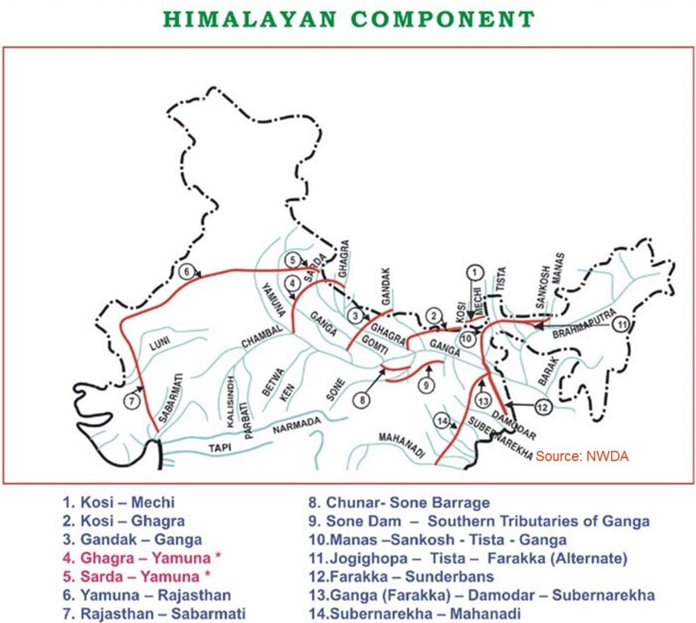
Himalayan Component: This component aims to construct storage reservoirs on the Ganga and Brahmaputra rivers, as well as their tributaries in India and Nepal.
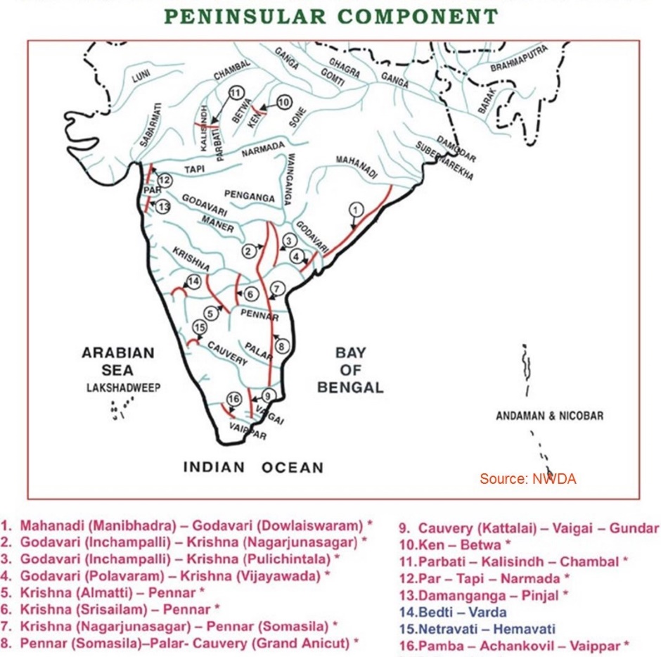
Peninsular Component or the Southern Water Grid: It envisages linking the Mahanadi and Godavari to feed the Krishna, Pennar, Cauvery, and Vaigai rivers. Besides this, the Ken River will also be linked to the Betwa, Parbati, Kalisindh, and Chambal rivers.
Intra-state inter-linking: This component explores the prospect of linking rivers within a state.
As of now, six projects — the Ken-Betwa, Damanganga- Pinjal, Par-Tapi-Narmada, Manas-Sankosh-Teesta-Ganga, Mahanadi-Godavari and Godavari-Cauvery (Grand Anicut) — have been under examination of the authorities.
The Central government is also working on the establishment of an exclusive body called National Interlinking of Rivers Authority to implement the projects.
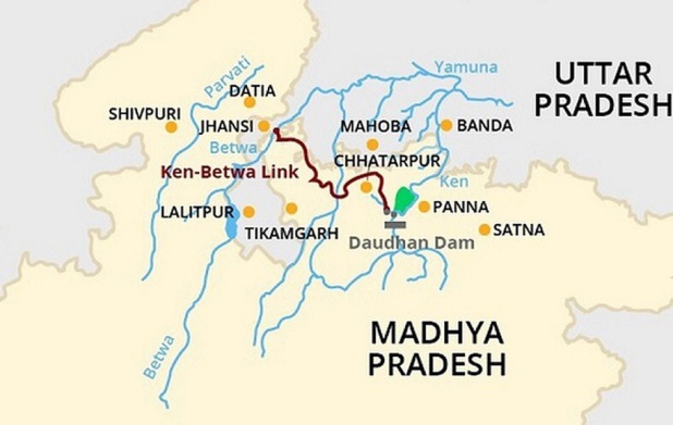
KEN BETWA PROJECT:
It is the first project under the National Perspective Plan for interlinking of rivers.
The project involves transferring of water from the Ken river to the Betwa river through the construction of Daudhan dam and a canal linking the two rivers, the Lower Orr Project, Kotha Barrage and the Bina Complex Multipurpose Project.
The project is slated to irrigate 10.62 lakh hectares annually, provide drinking water supply to 62 lakh people and generate 103 MW of hydropower and 27 MW of solar power.
The project is proposed to be ready in eight years and is expected to boost socio-economic prosperity in the backward Bundelkhand region.
WHY LINK RIVERS:
Meet rising demand:
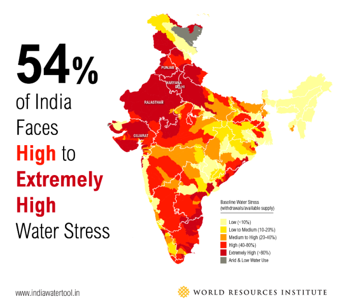
India has around 18 percent of the world’s population but only 4 percent of the usable water resources. By 2050, it is expected that India, as a whole, could be categorised as a 'water scarce'. To prevent this, river linking offers a solution.
Effective utilization of monsoon rain:
A large share of the country’s rain falls during the monsoon season (between July and September) and there is large special variation. Interlinking can effectively transfer the water to the deficit regions.
Encourage irrigated agriculture:
The rainfed areas constitute more than 50% of the total cropped area and account for more than 40 percent of the total food production(Source:ICAR). Interlinking of rivers will ensure year-round water availability and reduce dependence on monsoon rains. It in turn leads to increase in agri-productivity and farmers income.
Reduce exploitation of groundwater:
India is increasingly relying on groundwater to meet its domestic, agricultural and industrial needs, resulting in severe groundwater depletion and pollution. For instance, 90% of the groundwater consumed in India is used for irrigating crops, making it the primary water source for agriculture.
Linking rivers will ensure improved access to surface water, improves the quality and reduces the stress on groundwater.
Reduce floods and droughts:
About 12 % of land in India is prone to floods, while almost one-sixth area remains prone to drought. The river linking project will mitigate the impacts of recurrent floods in northern and eastern India while easing the water shortages in western and southern India.
Hydro power generation:
India needs clean energy to fuel its development processes, and river water can be leveraged for this. Himalayan rivers have immense hydro power potential, which can help India meet its rising demand for power.
Poverty alleviation:
Fulfilling water needs impact socio-economic life of people which will help end poverty. It also offers potential employment and income for rural areas through fishing and aquaculture.
Strengthen economy:
One bad monsoon has a direct and debilitating economic impact on India. River linking helps manage this risk and also offers the potential benefits of transportation through the waterways, thereby leading to reduction in logistics cost.
ISSUES IN RIVER LINKING:
Idealistic calculations:
The calculations of excess water rests on favorable conditions like sufficient rainfall, steady flow and other presumptive calculations. However, in reality, such calculations rarely hold true.
Ecological impact:
The ecology of every river is unique and letting the waters of two rivers mix may affect biodiversity. Also, construction of reservoirs results in submersion of large area of forest lands.
For instance, the Ken-Betwa link submerges about 7.6% of the total Panna Tiger Reserve area. Also, diversion of flood water will affect natural supply of nutrients for agricultural lands in the downstream areas, making agriculture less economic.
New climatic realities:
New anthropogenic factors clubbed with climatic aberrations has set the tone for an impending water crisis. Changes in the hydrological profile of Indian rivers could leave current surplus rivers with a deficit.
Cost of projects:
The cost for linking the Himalayan and peninsular rivers is estimated at Rs 5.5 lakh crore. This being a project that will take decades to complete, serious cost overruns can be expected. Hence, the cost-benefit ratio might not be favourable.
Displacement of people:
The projectsinvolve construction of massive networks of canals and dams, which would lead to large-scale displacement of people.
Eg: To implement the Ken-Betwa Project, the government will have to displace the people of ten villages in Chhatarpur district in Madhya Pradesh.
Difficulty in storing water:
The excess water received during monsoons should be held somewhere to be used in dry season, but the amount of water flowing in the short period of time, especially in Brahmaputra and Ganga, is too huge to be stored.
Transboundary water disputes:
International water disputes, such as those between India and Bangladesh, and interstate water disputes, such as the Cauvery water dispute between Karnataka and Tamil Nadu, are a major hurdle in the successful operation of river linking.
Hydro politics:
Water is an emotional issue for most part of the country. Political parties have leveraged them for mobilizing people. Hence, obtaining consensus among the various stakeholders is difficult.
Ignores water security:
A focus on such water infrastructure could lead to the so-called “reservoir effect,” where the construction of reservoirs can reduce the incentive to take other actions that could improve water security outcomes.
International experiences:
Efforts in other parts of the world yielded less than positive experiences. For eg: The diversion of water from Amu Darya and the Syr Darya in Afghanistan resulted in the rapid shrinking of the Aral Sea.
WAY FORWARD:
River linking was launched as a solution to the persistence of hunger and water insecurity in Indian society. However, such grand infrastructure projects are not the only way. There are a number of cheaper, socially and environmentally-benign options:
Increasing irrigation efficiency through measures such as micro irrigation.
Growing crops that are appropriate for the climatic conditions of the region in which they are grown.
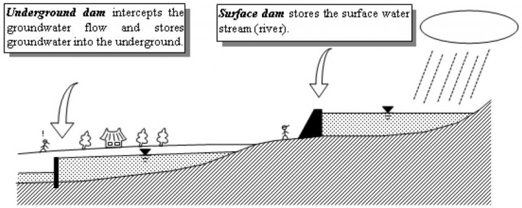
Arresting groundwater depletion through suitable recharging and creation of sub-surface dams.
Developing local solutions such as rainwater harvesting
Ensure that existing hydel infrastructure is maintained and operated to its full potential.
Making rainwater harvesting and groundwater management mandatory part of building codes.
Active involvement of grassroot democratic institutions in water conservation and management.
Developing a robust system of data collection of river regimes and forecasting of rainfall patterns.
Ensuring continuous dialogue and cooperation among stakeholders on the various aspects of water-sharing and management.
PRACTICE QUESTION:
Q. Critically analyse the role of river linking projects in addressing India’s water security concerns?(15 marks, 250 words)